British Columbia Institute of Technology
Department of Civil Engineering
Unit 1: Earthquakes


Seismicity of British Columbia
Seismicity of Canada
Seismologists locate an average of 1,500 earthquakes each year in Canada. Only about 100 of these measure more than magnitude 3 on the Richter scale or are felt by humans. Earthquakes of magnitude 6 or greater are strong enough to cause a significant damage. Geological Survey of Canada (GSC) is a Natural Resources Canada agency with a mandate to study and record earthquakes in Canada. The text and the figures presented in this section are a modified version of the material presented at the GSC's web site. For more information on seismic hazard in Canada and British Columbia refer to the Geological Survey of Canada and the Natural Resources Canada.
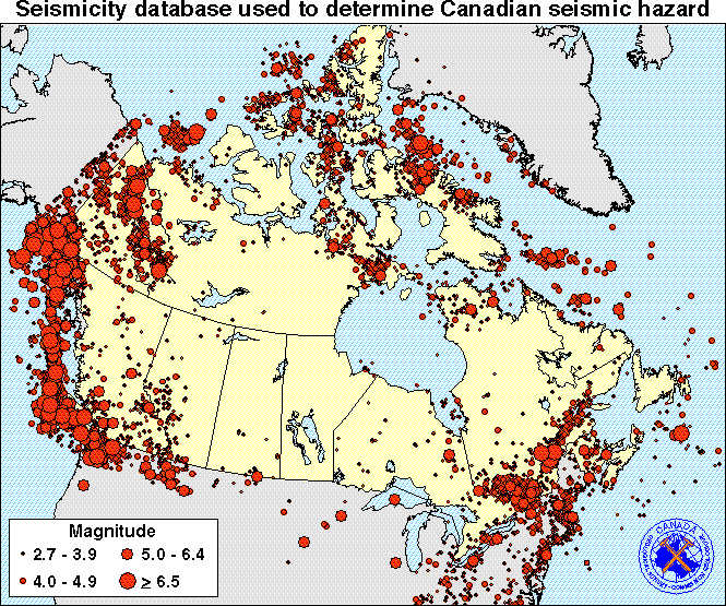
In the past, some parts of Canada have experienced more and larger earthquakes than others. Western Canada, and particularly the territory of British Columbia, is considered to be the most seismically prone area of Canada. Boundary between the North American and Pacific tectonic plates occurs along the west coast of the United States, Mexico and Canada. The San Andreas fault in California, the Juan de Fuca subduction fault off the Vancouver Island and the Aleutian Trench off the coast of Alaska are part of this boundary. These active seismic zones have generated earthquakes with Richter magnitudes greater than 8. Because earthquakes always occur along faults, the seismic hazard is greater for the population centres located close to active fault zones.
In the eastern part of Canada and the United States, the cause of earthquakes is less well understood. There is no plate boundary and very few locations of faults are known. In the past, several earthquakes have occurred in the eastern USA, e.g. New Madrid, Missouri, 1811 & 1812, indicating that there is a potential for very large earthquakes. Smaller but still damaging earthquakes, up to Richter magnitude 7, have occurred near St. Lawrence and Ottawa rivers (La Malbaie, 1926, Cornwall-Massena, 1944, Saguenay, 1988). Because of regional geologic differences, eastern and central North America earthquakes are felt at much greater distances than those in the western part, sometimes up to 1000 km away.
In the central part of Canada, no significant earthquake risk exists, while in the Arctic regions some moderate seismic activity is predicted.
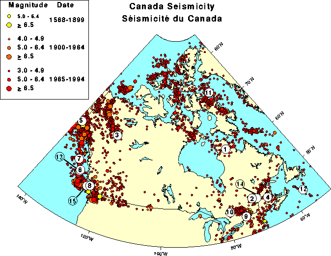
The largest earthquake in Canada this century (magnitude 8.1) occurred in 1949 in the sparsely populated Queen Charlotte Islands, British Columbia. In 1929, 27 people drowned in a tsunami (large ocean wave) generated by an offshore earthquake of magnitude 7.2 south of Newfoundland. A magnitude 6 earthquake in the Saguenay region of Quebec in November 1988 caused tens of millions of dollars in damage.
A map of Canada, showing Canadian earthquakes of magnitude 3 and higher that occurred in the 20th Century, is shown below. The major Canadian earthquakes of the 20th century are denoted with numbers 1 to 20.
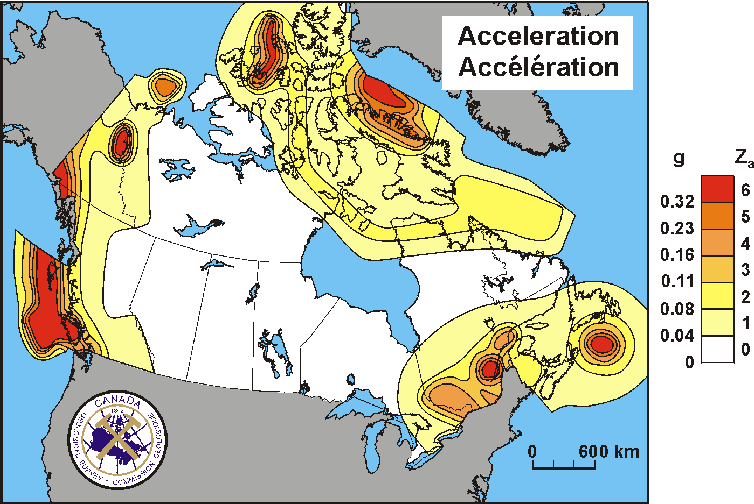
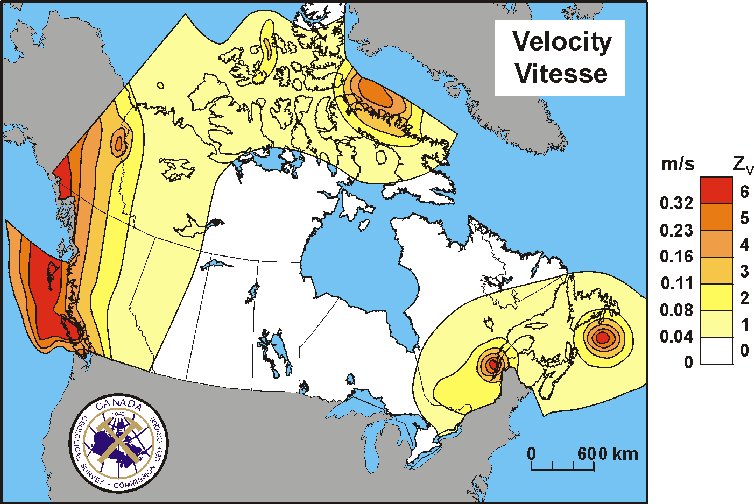
Seismic zoning maps for Canada are derived from the analysis of past earthquakes, and from advancing knowledge of Canada's tectonic and geological structure. Depending on the expected seismic hazard and intensity of ground shaking expressed in terms of ground acceleration (expressed as a fraction of the acceleration of gravity g), the territory of Canada is divided into 7 seismic zones i.e. zones 0 to 6. Zone 0 is characterized with a very low seismic hazard, whereas zone 6 is characterized with the highest seismic hazard in Canada.
Each seismic zone is characterized with Zonal Acceleration (Za) and Zonal Velocity (Zv) factor. Two seismic zoning maps, one based on the Za factor, and the other based on the Zv factor, are included in the 1995 National Building Code of Canada. The two maps are shown on the figures below. Note that the areas of the highest seismic hazard in Canada (i.e. seismic zone 6) are highlighted in red colour, whereas the areas of a very low seismic hazard are white.
One of the maps shows maximum horizontal ground velocity i.e. Zv value (in m/s) and it is appropriate for the seismic design of tall and slender structures; the velocity map shows maximum shaking centered near 1 Hz (corresponding to a period of 1 sec.). The other map shows maximum horizontal ground acceleration i.e. Za factor and is appropriate for seismic design of low-rise and rigid structures; the acceleration map shows shaking centered at about 5 Hz (corresponding to the fundamental period of 0.2 sec.). It is important to have two different maps showing the maximum shaking at two different frequencies because different buildings are susceptible to different frequencies of earth motion. Damage is caused by resonance between the earthquake ground motion and the building's own natural frequency. A high-rise of 10-stories or more will sway with a natural period of 1 or 2 seconds, whereas a bungalow will vibrate at about 10 Hz.
Note that the Appendix C of the 1995 National Building Code of Canada lists Za and Zv values for most localities in Canada; in total, 12 different localities are identified for the Greater Vancouver area.
Seismicity of British Columbia
The Pacific Coast is the most earthquake-prone region of Canada. In the offshore region to the west of Vancouver Island, more than 100 earthquakes of magnitude 5 or greater (large enough to cause damage had they been closer to land) have occurred during the past 70 years. The reason for the concentration of earthquakes along the west coast is the active faults, or breaks in the earth's crust that occur in this area.
The west coast of Canada is one of the few areas in the world where four tectonic plates meet and interact, and three different types of plate movements take place, resulting in significant earthquake activity. Plates move towards each other at converging, apart at diverging and past each other at transform boundaries. All three of these boundary types occur in offshore B.C.
About 200 kilometers off the west coast of Vancouver island, the Juan de Fuca plate and Pacific plate are diverging or spreading apart along the Juan de Fuca ridge. Further east, the Juan de Fuca plate is converging with and sliding (subducting) beneath the North American plate at about 2-5 cm/year. This region is called the Cascadia subduction zone; it is located about 45 km beneath Victoria, and about 70 km beneath Vancouver. Another small plate, the Explorer, is also sliding underneath the North American plate, and at the same time the Juan de Fuca plate is sliding along the Nootka fault. In the north, there is a major transform fault boundary between the Pacific and the North American plates called the Queen Charlotte fault. This fault was the site, in 1949, of Canada's largest earthquake. The tectonic plates meeting off the B.C. coast are illustrated in the figure below.
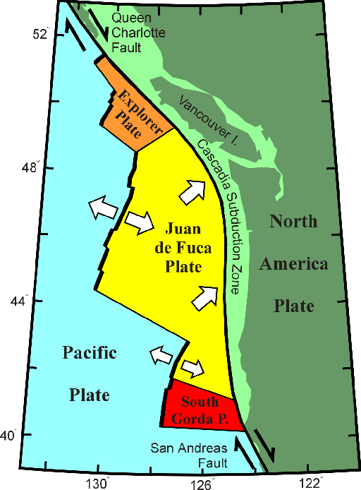
The ocean plate is not always moving though. There is good evidence that the Juan de Fuca and North America plates are currently locked together, causing strain to build up in the earth's crust. It is this squeezing of the crust that causes the 300 or so small earthquakes that are located in southwestern British Columbia each year, and the less frequent (once per decade, on average), damaging crustal earthquakes e.g. a magnitude 7.3 earthquake on central Vancouver Island in 1946. At some time in the future, these plates will snap loose, generating a huge offshore "subduction" earthquake - one similar to the 1964 M 9.2 Alaska earthquake, or the 1960 M 9.5 Chile earthquake. Current crustal deformation movements in this area provide evidence for this model. There is also a geological evidence indicating that huge subduction earthquakes have struck this coast every 300-800 years. To read a detailed paper on subduction earthquakes in British Columbia click here.
Several major earthquakes that happened in the Washington - B.C. region in the past 150 years are listed in the table below.
LARGE EARTHQUAKES IN THE PAST
| Year | Region | Magnitude | Comment |
| 1872 | Washington-B.C. border | 7.4 | Widely felt in B.C. |
| 1899 | Yukon-Alaska border | 8.0 | Widely felt in north-western B.C. |
| 1918 | Vancouver Island | 7.0 | Widely felt, minor damage |
| 1929 | Queen Charlotte Islands | 7.0 | Widely felt, minor damage |
| 1946 | Vancouver Island | 7.3 | Widely felt, most damaging quake in western Canada |
| 1949 | Queen Charlotte Islands | 8.1 | Largest quake in Canada, one of the world's greatest quakes |
| 1949 | Washington | 7.0 | Much damage in Washington and felt in southwestern B.C. |
| 1958 | Alaska-B.C. border | 7.9 | Damage in Alaska, widely felt in northwestern B.C. |
| 1964 | Alaska | 9.2 | Tsunami damage on Vancouver island |
| 1970 | Queen Charlotte Islands | 7.4 | Widely felt. |
Go to Measuring Earthquakes.